We earn a commission from third-party booking links, at no extra cost to you
Bermuda Beaches Map: Locations, Regions and Transport Guide
Updated: August 2026
I have spent years exploring Bermuda's coastlines. With over 34 distinct beaches scattered across very different parishes, figuring out where to lay your towel can be confusing. Looking at a standard map does not always tell you if a beach has public bathrooms or if it requires a hike down a steep limestone cliff.
This guide breaks down the island's coastal geography. I will help you understand the layout so you can plan your beach-hopping logistics with total confidence. Here is a quick snapshot of what to expect:
At a Glance
| Data Point |
Details |
| Best Time for Beaches |
May through October for warm swimming water. |
| Primary Transport |
Public Bus (Route #7), scooter or electric mini-car rental. |
| Cost Estimate |
Free entry for most beaches; $20 - $25 for chair rentals where available. |
| Ideal Duration |
Plan for 3 to 4 hours per major beach stop. |
| Top Regional Hub |
The South Shore for the famous pink sand. |
Common Mistakes When Navigating
Do not assume a beach is easily accessible just because it looks close to the main road on your screen. Church Bay, for example, appears right off the street on a map. In reality, it requires walking down a steep, often slippery set of wooden and limestone stairs.
Another frequent trap is taking a taxi to a remote spot like Clearwater Beach without a return plan. Taxis do not wait at the East End nature reserves. Always arrange a specific pickup time with your driver before they drop you off.
Accessibility
Not all beaches are created equal when it comes to mobility. If you are traveling with a stroller or require wheelchair access, Shelly Bay and Clearwater Beach are your best options. They offer flat approaches and easy parking. Avoid spots like Church Bay or Jobson's Cove, which require navigating steep stairs or deep, soft sand.
Who This Guide Is For
This page is built for trip planners, cruise visitors, and anyone looking to build a realistic itinerary based on location. If you need to know which beaches are near the cruise port or how to group them by bus route, you are in the right place.
If you just want a ranked list of the most beautiful spots to swim or snorkel, you should skip this map guide. Instead, head over to my deep-dive article on the
Best Bermuda Beaches for full reviews and rankings.
The Bermuda Beaches Map
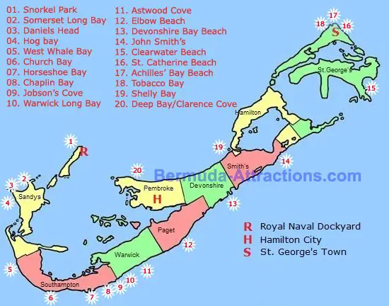
The map below shows the location of the popular beaches in the island. Click a beach marker to get detailed description of the beach along with its pictures, facilities available, how to reach, and more.
Click a beach# to know about the beach
Use the map below to get your bearings. I have categorized the beaches by region so you can easily see how they cluster together.
Interactive Map of Bermuda Beaches (With Road Map)
You can click on any pin to see the exact name of the beach and its location on Google map. I highly recommend saving a version of this map to your phone so you have it ready while you travel around the island.
Understanding Beach Locations by Region
Bermuda is shaped like a fishhook. The coastline changes dramatically depending on which part of the hook you are standing on. Here is how the regions break down.
The South Shore (The Pink Sand Hub)
This is the most famous stretch of coastline. If you want the iconic pink sand and dramatic rock formations, this is where you need to be.
Major stops here include
Horseshoe Bay,
Warwick Long Bay,
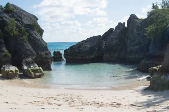
Jobson's Cove, and
Church Bay. The water here can get rougher than the rest of the island, especially when the wind picks up from the south. This entire corridor is serviced by Bus Route #7, making it incredibly easy to navigate without a vehicle.
The West End (Closest to Cruise Ships)
Cruise passengers arriving at the Royal Naval Dockyard will find the West End beaches incredibly convenient. These shores lack the massive pink sand expanses of the south, but they make up for it with proximity.
Snorkel Park is located right at the Dockyard. Alternatively, a short ride brings you to
Somerset Long Bay and
Daniel's Head. These spots provide a perfect quick dip if you only have a few hours before your ship departs.
The East End (Historic and Secluded)
The East End surrounds the historic town of St. George's and the airport. The beaches here feel a bit more rugged and secluded.
Tobacco Bay is famous for its shallow, warm water and lively beach bar. Further out, you will find
Clearwater Beach and
St. Catherine's Beach. These are excellent options if you want to escape the heavy crowds that flock to the South Shore during peak summer months.
The North Shore and Central
Leaving the rugged coves of the east behind, the northern and central coastlines offer a completely different experience. The North Shore does not have as many sandy beaches, but the water is typically much calmer and flatter.
Shelly Bay is a standout here, offering shallow water that stays waist-deep for a long distance.
Closer to the center of the island,
Elbow Beach offers a massive stretch of sand that feels very exclusive. Half of it is open to the public, making it a great alternative to the busier southern spots. Note that the adjacent historic Elbow Beach Hotel is currently closed and undergoing a major luxury redevelopment by The Loren Group.
Snorkeling Beaches
If you are specifically looking for the best snorkeling beaches in Bermuda, here is the list:
Church Bay Beach on South Shore (in Southampton Parish)
Tobacco Bay (in St. George's Parish)
Jobson's Cove on South Shore (Warwick Parish)
Snorkel Park Beach in Royal Naval Dockyard (Cruise Port)
Daniel's Head Beach in the west (Sandys Parish)
Shelly Bay Beach, excellent for beginners (Hamilton Parish)
What Surprises Visitors the Most
When you look at a map, the South Shore beaches look like separate, distinct points. What the screen does not show you is the incredible trail system linking them together.
A
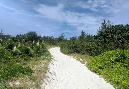
sandy walking trail connects Horseshoe Bay all the way to Warwick Long Bay. You can walk through the dunes and coastal grass, popping out at half a dozen secluded coves along the way. You do not need to get back on the road to hop between these beaches.
Pro-Tip: Wear sturdy sandals for the South Shore trails. The sand can get uncomfortably hot by midday, and you will occasionally have to step over uneven terrain.
Practical Details: Getting to the Beaches
The public bus system is the cheapest way to navigate the beaches. Look for the pink and blue bus poles to guide you, and remember that Route #7 is your best friend for the South Shore.
If you rent an electric mini-car, parking is generally free and easy at the major beaches. However, spots fill up fast at Horseshoe Bay between 10 am - 2 pm.
Know your facilities before you go. Horseshoe Bay, Tobacco Bay, and Clearwater Beach have bathrooms and food concessions. Most other beaches, like Jobson's Cove, are natural reserves with zero facilities, though Warwick Long Bay does offer public restrooms and a seasonal summer concession stand. Pack your own water and snacks.
Alternatives and Next Steps
If you need a broader view of the island's parishes, ferry routes, and major attractions, review my master navigation guide:
Map of Bermuda.
If you are trying to figure out where to stay in relation to these beaches, check out my accommodation guide:
Bermuda Hotel Map.
About the Author
 By Raj Bhattacharya
Raj has been writing about Bermuda since 2008, when he launched bermuda-attractions.com, one of the longest-standing independent guides to the island. A Certified Bermuda Specialist (Bermuda Tourism Authority), his work draws on personal visits, local contacts in Bermuda, and questions and trip reports from thousands of readers over the years.
Learn more about Raj Bhattacharya
Related Articles
|
Visitors' Reviews and Comments
|