We earn a commission from third-party booking links, at no extra cost to you
Map of Hamilton, Bermuda: Tourist and Navigation Guide
Updated: September 2026
Navigating the capital city of Bermuda is highly straightforward if you understand the basic layout. Hamilton is a compact, grid-based harbor city designed for walking.
Whether you are stepping off a ferry for a day trip or walking from a nearby hotel, you can cross the entire downtown area in about fifteen minutes.
Hamilton Road Map with Landmarks
Use the map above to pinpoint exactly where you want to go. Then, read on for practical tips on how the street grid actually works on the ground.
At a Glance: Navigating the City
This map is designed for walkers, cruise visitors, and architecture buffs exploring the capital. If you are looking for a map of expansive nature trails or beaches, you should skip this guide. There are no beaches within the city limits.
What surprises most visitors is the topography. A digital map looks completely flat on your screen. However, walking just two blocks north from the harbor introduces a noticeable, sweaty incline.
You will feel the humidity hit you as you walk up Burnaby Hill past the post office. Keep this in mind if you are visiting during the peak summer months of July or August.
Understanding the Grid (How to Orient Yourself)
You do not need to constantly stare at your phone to get around. The easiest way to orient yourself is to use
Front Street as your permanent southern baseline. Front Street runs directly along the water. If you can smell the harbor salt and see the boats, you are at the bottom of the grid.
The main East-West arteries run parallel to the water. Moving north from Front Street, you will cross Reid Street, Church Street, and Victoria Street.
The main North-South cross streets intersect these arteries. From west to east, the major roads are Queen Street, Burnaby Street, Parliament Street, Court Street, and King Street.
Hamilton Tourist Map: Landmarks and Transit Hubs
Hamilton serves as the central nervous system for Bermuda transit. The Ferry Terminal sits right on the western edge of Front Street. This is your main gateway if you are coming from the Dockyard.
Just a short walk inland, you will find the Central Bus Terminal located on Washington Street. This terminal connects you to almost every other parish. The smaller cruise ship berths are also located directly along the Front Street waterfront.
For sightseeing, start at
City Hall and the
Cathedral of the Most Holy Trinity, both located on Church Street. You can read more about the cathedral's stunning architecture in my
Hamilton Cathedral guide.
Further east, you will find the historic
Cabinet Building. If you are willing to walk up a steep hill on the eastern edge of the city, check out my
Fort Hamilton guide for details on exploring the 19th-century moats and gardens.
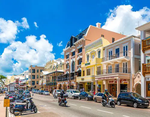
Front Street - Hamilton, Bermuda
Photo: Darryl Brooks, Shutterstock
Looking for the Hamilton Shopping Map?
Retail zones in the city are highly concentrated. Because store hours and boutique locations change frequently, I keep all retail details on a separate page.
If you are looking for the entrances to the
Washington Mall or high-end boutiques along Front Street, head directly over to my dedicated
Hamilton Shopping Map. That guide includes exact store locations, current opening hours, and local buying tips.
Practical Details for Map Users
If you prefer a physical paper map, you need to know where to look. The old shipping-container Visitor's Services Center on Front Street was permanently dismantled. You should pick up a paper map at the relocated Visitor's Services Center right next to the Ferry Terminal or at the visitor desk inside City Hall.
For digital access, free public Wi-Fi can be spotty on the streets. Load your digital maps while you are sitting in a cafe on Reid Street or while connected to the Wi-Fi at the Ferry Terminal.
Public restrooms are crucial for walkers. The most reliable and clean public facilities are located right next to the Ferry Terminal and inside the upper levels of the Washington Mall. Be aware that the tiled steps near the ferry restrooms can be highly slippery after a brief rain shower.
Pro-Tip: Cash for Street Vendors
While almost all brick-and-mortar stores take credit cards, you will want small US or Bermuda cash bills if you plan to buy a cold drink or a snack from the independent carts parked near the harbor.
Common Navigation Mistakes
The biggest mistake visitors make is renting a Twizy or a scooter just to get around Hamilton. The city is packed with one-way streets, strict parking zones, and heavy rush-hour traffic.
Walking is almost always faster than driving if you are staying within the city grid. Save the rental vehicles for exploring the outer parishes.
Another common error is underestimating the walk to Fort Hamilton. It looks close on the map, but the steep uphill grade in the midday heat can be exhausting. Bring a water bottle and take your time.
Alternatives to Hamilton
If a busy commercial grid is not what you are looking for, you have other options. If you want a historical walking map filled with 17th-century cobblestone alleys, use my
St. George's Map.
If you want a highly contained, pedestrian-only cruise hub with immediate access to museums and pubs, check out my
Royal Naval Dockyard Map.
About the Author
 By Raj Bhattacharya
Raj has been writing about Bermuda since 2008, when he launched bermuda-attractions.com, one of the longest-standing independent guides to the island. A Certified Bermuda Specialist (Bermuda Tourism Authority), his work draws on personal visits, local contacts in Bermuda, and questions and trip reports from thousands of readers over the years.
Learn more about Raj Bhattacharya
Related Articles
1) Check out
Hamilton Bermuda for attractions, activities and other information about Hamilton city.
2) Check out
Pembroke Parish know about the parish where Hamilton City is located and also about all its attractions, activities, restaurants, hotels and more.