We earn a commission from third-party booking links, at no extra cost to you
Ferry Reach Park (Ferry Point Park) Bermuda
Ferry Reach Park is located at the end of Ferry Road at the western Peninsula of St. George's Parish and also known as Ferry Point Park. This 64 acres park area is the second largest in Bermuda and has wonderful walking trails, forest areas with endemic plantation, a nice lake, a bay with a lovely beach, and a few historic forts. Other than the sounds of airplanes flying overhead at times, this place has remained as a serene and peaceful parkland over the years.
📖 Planning a trip to Bermuda?
Get our practical Bermuda travel guides with insider tips and ready-to-use planning insights.
View Guides
Used by thousands of travelers planning Bermuda trips
So if you like to go out with your family and kids and enjoy the day, or like to just stroll around exploring the lovely landscapes, this is the place to go.
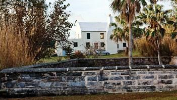
At the entrance of the park is the Ferryman's Cottage. It's a two storied whitewashed house reflecting the typical old Bermudian architecture and made of limestone. While the exact origin of the house is unknown, we heard that it used to be a cottage that belonged to a ferryman way back in the 1600s. This was the time when ferry used to be the only transport that connected the main land of Bermuda with St. George, and the Ferry Dock at the western end of the park was where people boarded the ferry or disembarked.
Ferryman's Cottage Bermuda
Subsequently in 1781, the British garrisons occupied this building and used it as their barrack.
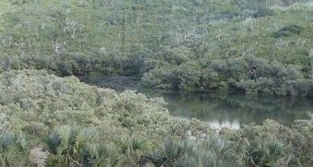
Go towards the eastern side of the park through the maze of lovely trails, and you will see the secluded Lovers Lake. Bermuda government maintains the lake and the surroundings as a nature reserve. The greenish-blue water is surrounded by mangroves on all sides.
Lovers Lake
In the surrounding hilly areas you will see many ferns and skeletons of
Bermuda cedars. During the spring time, many different kinds of glowers blossom here including Bermudiana, Jamaican vervain and speedwell.
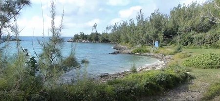
At the western side of the park, there is Whalebone Bay Beach with a backdrop of casuarinas and palm trees. The view from here out to the open ocean is spectacular. If you love snorkeling, this place can be really rewarding. You can see many coral reef fish in the waters here.
Whalebone Bay Beach
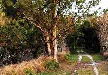
Bermuda Railway Trail passes through the park and goes along the western coast line. Bermuda's railway track was once laid along this route which has now become a lovely walking trail.
As you walk along the trail and through the bushy areas, look out for the herons, and on the coastline for the occasional seagulls.
Railway Trail through Ferry Reach Park
A rich man named Vincent Astor acquired a 22 acre land area next to the park and built his mansion in 1930s. His property was known as
Astor Estate. He built his own mini railway to reach out to the various parts of his vast property. He even connected his private track to the main Bermuda railway tracks at a point known today as the
Ferry Point Junction. Astor's Halt was the name of the private train stop. Inside the building here you can still see remains of the track.
At the western most tip, the peninsula of the Ferry Reach Park forms shape of a thumb with an area of 1.5 acres. This is called the
Ferry Island which can be accessed from the park on a small wooden bridge. It was in Ferry Island where the ferry dock was built way back in 1600s.
Ferries transported people across to the other side known as
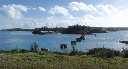
Coney Island which connects to the mainland of Bermuda. For over 250 years, ferry was the only transport that connected St. George with the main island. It ceased to operate once the
Causeway was built in 1871.
View of Coney Island from Ferry Reach Park
In 1931, the Bermuda Government inaugurated the part of the railway track that connected these two points over the water channel. Although the track does not exist today, you can still see the structures that supported the track (see the above picture).
There are three historical forts in the park area. The forts were all built on hilly grounds to get vantage points.
Burnt Point Fort was built in 1688 to primarily stop illegal trading by local sailors. This is the time when Spanish were considered the main British enemies. So the fort also doubled up against possible attacks from the Spanish.
The
Ferry Island Fort located on Ferry Island was originally built in 1790s and went through reconstructions over the next 80 years.
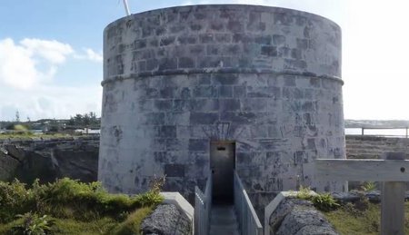
In 1823,
Martello Tower came up on the high ground behind the two forts where soldiers could survey the surrounding coastline and the land area. A magazine was also built nearby along with the tower which could store 220 barrels of gunpowder.
Martello Tower Bermuda
During 1950s when Yellow Fever became an epidemic in Bermuda, many British soldiers used the park area to isolate themselves from mosquito bites. They put up tents all across the park including in the areas surrounding the forts and Ferryman's Cottage. Unfortunately, they were not aware that this park itself was the breeding ground of the disease carrying mosquitoes. And eventually many died.
There are two cemeteries maintained by the
Bermuda National Trust that reflect the sad old memories. One such cemetery on a hill side close to the Whalebone Bay is dedicated to the Second Battalion of Queen's Royal Rifles who were buried in 1864. Now only a large marble cross stands there. The second cemetery is close to the Ferryman's Cottage. This ground was once used for keeping farm animals. There are no graves marked here.
Ferry Reach Park is a great place for families and children. Whether you get your kids to jump over the rocks on the coastline, play in a tidal pool, snorkel or collect shells, explore the historic forts, take photographs of the wonderful views and enjoy walking the trails, this is a place a family can cherish for a long time.
Ferry Reach Park is open daily during the day time. There is no admission fee.
How to Reach
Ferry Reach Park is located at St. George's Parish. Public bus services #1, 3, 10, 11 (operating between Hamilton City and St. George's) come nearby. You will need to get off at the junction of Mullet Bay Road and
Ferry Road. The Ferry Reach Park is at the end of Ferry Road and takes about 25 minutes walk from the junction.
Road Map
About the Author
 By Raj Bhattacharya
Raj has been writing about Bermuda since 2008, when he launched bermuda-attractions.com, one of the longest-standing independent guides to the island. A Certified Bermuda Specialist (Bermuda Tourism Authority), his work draws on personal visits, local contacts in Bermuda, and questions and trip reports from thousands of readers over the years.
Related Articles
4)
Bermuda Tours: Know about many other great tours and excursions in Bermuda.
|
Visitors' Reviews and Comments
Review and share your experience.
|