Bermuda Railway Trail
You will love to walk or cycle
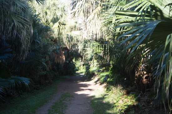
What used to be a railway track once, is now converted into an excellent walking trail in Bermuda. In 1948 the Bermuda government closed down the railways as they thought it was no longer required. And in 1984 they transformed this into a wonderful nature trail for the walkers and cyclists.
The railway trail is undoubtedly the most scenic trail in Bermuda and offers a wonderful way of exploring the island from one end to the other. However, out of 21.8 miles of the original railway track, you can now access about 18 miles.
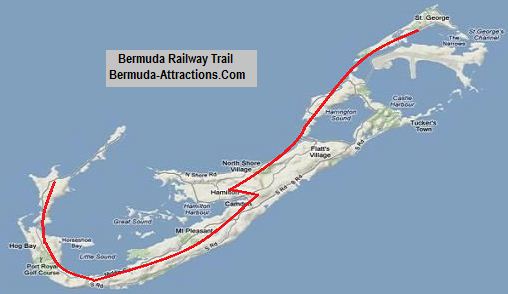
Bermuda Railway Trail (the red line)
As you can see in the picture above, the railway trail is laid out between Somerset at the western end, goes through the central parishes including Hamilton City and all the way up to St George's at the eastern end.
Several sections of the trail run along the north shore of Bermuda offering great views of the northern coastline.
📖 Planning a trip to Bermuda?
Get our practical Bermuda travel guides with insider tips and ready-to-use planning insights.
View Guides
Used by thousands of travelers planning Bermuda trips
The Background of Bermuda Railways
Regular passenger service in the western section began on October 31, 1931 and on December 19 of the same year in the eastern section, operating from 6am until midnight at one to two-hour intervals, depending on the time of the day.
The cost of establishing the railways was estimated to be £1 million. At that time, the cost of construction per mile of Bermuda's railway was more than any other railway in the world.
The original rolling stock (i.e. locomotives, passenger carriages, etc) for the Bermuda railway was built at Preston, Lancashire works of English Electric Company, and that included the following:
Six 14-ton 42-inch long first class passenger coaches (Pullmans)
Two 120-hp 32-inch long, 20-ton petrol-engined motorized freight vans
Two 14-ton trailer freight vans
Six 120-hp, 20-ton petrol-engined composite first class (seating 16) and second class (seating 26) passenger cars
Locomotives and carriages were transported by cargo ships and mostly offloaded at Hamilton Harbor.
Railways in Bermuda was widely used in the 1930s by commuters, schoolchildren, and shoppers since private automobiles were not allowed in Bermuda until 1946.
The railway tracks were laid all along the northern coast line offering marvelous views of the ocean. Tourists, in particular, enjoyed the spectacularly scenic ride along the northern coastline and through Bermuda's flower-covered hills.
Those days, special sightseeing excursions were run by the Bermuda Railways for cruise ship passengers.
Slowly the maintenance was becoming very expensive. Many sections of the 22-mile long railway tracks were on wooden or metal bridges that crossed various parts of the ocean, and were becoming difficult to maintain.
Rot and corrosion was another major problem. So in 1948, the Bermuda government decided to close down the railways for good.
Today, the railway track has become a wonderful walking and cycling trail. It's not quite possible to walk the entire trail in just one day. Tribe Roads (that crisscross the island) reach up to the Railway Trail and the coastline at various points.
So choose your section and get into the trail at any point you like. It's a wonderful place to hike, run or cycle. If you are looking for some variations along the way, get off the railway trail and head to a beach for a swim or walk in the sand.
A short video of Bermuda Railway Trail
Railway Trail Sections From west to east
The following seven sections of the Railway Trail pass through the different parishes of Bermuda. A section would take between 1 to 3 hours of walk depending on its span.
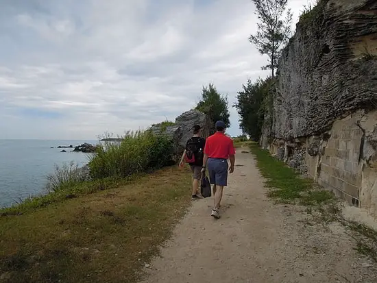
Photo: slgckgc, cc by 2.0
NOTE FOR BIKERS
There are several metal barriers along the railway trail... this is to keep the vehicles away. You need to lift your cycle over the barriers and then continue.
And there are also several rocky and rough patches (including ravines over which railway bridges once existed) where it won't be easy to cycle. However, if you are physically fit enough, take these as your challenges and cycling too would be rewarding.
Section-1
The first section of the trail starts from Somerset Bus Stop at the western end of Bermuda. If your cruise ship is docked at Royal Naval Dockyard (i.e. the Kings Wharf Cruise Port), you can take bus #7 or 8.
Come down to Somerset Bus Stop (2.6 miles from the dockyard bus stop) and then get into the trail through Beacon Hill Road entrance.
This Somerset Bus Terminal once used to be the Bermuda Railway Terminal. The trail here stretches for 2 miles towards east up to the
Somerset bridge.
The entry points to the railway trail in this section are:
- Beacon Hill Road (off Somerset Road)
- Scotts Hill Road (off Somerset Road),
- Sound View Road (off Somerset Road),
- Scaur Hill Fort Park,
- Lantana Colony Club,
- Wharf Drive (Somerset Bridge)
Section-2
This section, also in
Sandy's Parish, starts from Somerset bridge and goes up to Overplus lane near Evans pond. You will pass by the following areas in this stretch:
Harmon's Bay
Skroggins Bay
The entry points in this section are:
- Wharf Drive (Somerset Bridge)
- George's Bay Road
Section-3
This stretch, a relatively longer one, goes mainly through
Southampton Parish and some parts through
Warwick Parish. You will need to access it from Overplus lane and it ends near Warwick pond.
Southampton Railway Trail (facing east)
In this section of the trail, you will pass by the following landmarks:
Evans Pond. You can see Bermuda cedar trees and birds like herons here.
A former railway station at the junction of Whale Bay Road which is turned into a Sunday school now. If you leave the trail and walk along the Whale Bay Road, you will reach our favorite Whale Bay Beach and Park.
Evans Bay
Superb views of Great Sound and Black Bay
Jews Bay
Riddell's Bay and look for the old Riddell's Bay railway station here
Warwick Ridge Park. This is an woodland area and you will see a lot of allspice trees. This part of the trail goes through the adjacent Warwick Parish.
Pembroke Hamilton Club where cricket and soccer matches are held
Southampton Railway Trail (facing west)
The entry points to the trail in this section are:
- Tribe Road #5
- Opposite to Whale Bay Road
- Franks Bay
- Junction of Middle Road and South Road
- Church Road
- Tribe Road #2
- Lighthouse Road
- Camp Hill Road
- Khyber Pass
Section-4
This section of the Bermuda Railway Trail passes through
Paget Parish. From Paget, you can enter the trail at Trimingham Hill on South Road.
There are signs for the trail. Although the trail crosses the main roads a few times, it quickly re-enters the tranquil stretches of farm lands and spice forests.
You can see and/or easily get to:
Old houses with typical Bermudian style.
Surinam Cherry Bushes
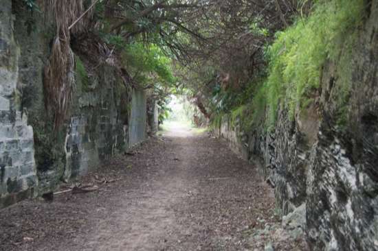
Railway Tunnel
The entry points to the railway trail in this section are:
- Ord Road
- Cobbs Hill Road
- Ord Road (South Hill)
- South road (Harmony Road)
- South Road Round About
From Paget when you enter Hamilton City in Pembroke Parish, you will notice that a long section of the railway trail is missing. This part of the original railway track has not been converted into the trail due to Hamilton's population and other city requirements.
Palmetto Road to Rural Hill section is actually a detour from the original railway route that passed through Hamilton City.
There are short segments where the trail joins a road without sidewalks and there are several points where the trail crosses busy roads... so you need to use caution.
The next section starts from Devonshire as described below.
Section-5
Most part of this stretch passes through
Devonshire Parish and some part passes through
Smith's Parish. You get a marvelous view of the north shore from various parts of the trail.
You will see the main channel of cruise ships for entering the Great Sound and Hamilton Harbor.
Devonshire Railway Trail
The stretch starts from the East Palmetto Park and ends at Flatts (the distance of this section is 2.3 miles and estimated walking time is about 2 hours). You can see and/or easily get to:
Palmetto Park
Penhurst park which stretches from the North road to the Middle road and the trail goes through it.
Gibbet Island
Devonshire Footbridge on Railway trail
Entry points in this section are:
- Palmetto Road
- Barker's Hill
- Store Hill
- North Shore Road (Jennings)
Section-6
This section of the railway trail passes through
Hamilton Parish. This is one of the most picturesque sections of the entire trail.
You can see and/or easily get to:
Bermuda Railway Museum. Once this building used to be a Railway Station that catered to the Bermuda Aquarium, Museum and Zoo. But the museum has closed down now.
Ruins of old chimneys used in making ships
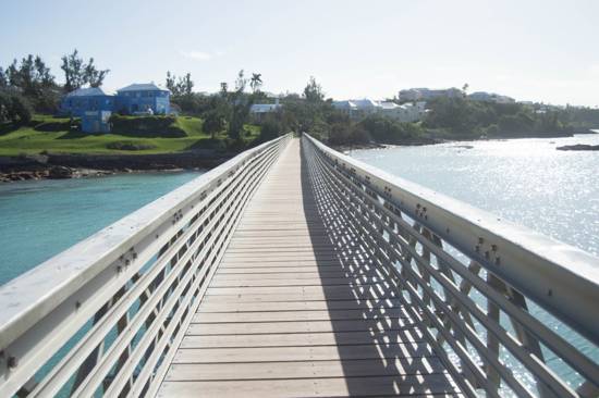
In December 2014 a 740-ft long metal footbridge was built over Bailey's bay in Hamilton parish. It is part of the Railway Trail. This footbridge offers wonderful view of the waters. This footbridge attracts a lot of parish residents and tourists on this section of the trail.
Bailey's Bay Footbridge (part of railway trail)
Entry points to the railway trail in this sections are:
- North Shore Road (Bermuda Aquarium, Museum and Zoo)
- Bermuda Railway Museum
- North Shore Road (Shelly Bay / Old Road)
- Bailey's Road
- Coney Island Road
Here is a little description of this picturesque section:
Keep walking along the trail and you will get lovely views of the north shore and then Shelly Bay. As you get to Shelly Bay Park and Beach the trail ends and you need to get on to the Old Road.
The Old Road finally meets the North Shore Road where Shekinah Worship Center building is located. The sidewalk on North Shore Road leads all the way to the next section of the trail (just past the Esso Crawl Hill Gas Station).
Keep walking and you will reach the long footbridge with aluminum rails I described above. Look around and soak in the wonderful view of Bailey's Bay.
Once you cross the bridge, another one-third mile away you will come to Coney Island Road. If you turn right, you will get on to North Shore Road again.
But if you are willing to walk a little extra and follow the original rail route, then turn left, keep walking along Coney Island Road to its end and you will reach Coney Island Park. You can't go any further, but the view of the water from here is awesome.
Towards east you can see the Ferry Island across the water. There used to be a railway bridge here. And even before the railway was introduced, a ferry used to once ply between these two islands that provided the only connection.
Get back along Coney Island Road and get on to North Shore Road. Within a short walk from here you will find Swizzle Inn Pub and you can relish a Rum Swizzle here.
Across the road you can savor a yummy island flavored ice cream at
Bailey's Ice Cream Parlor (they are usually open only during the summer months).
This is roughly about a 5-mile walk (including the detour to Coney Island Park). You will get bus #10 and 11 (as well as #1 and 3) from here to return to Hamilton City or St. George.
Section-7
The stretch goes through
St. George parish. It starts from
Ferry Point or the Ferry Reach Park at the end of Ferry Road. Within the park, the trail goes through lovely woodland areas and then along the coastline at the western end of the park.
You will see the oil docks which are still in use and you can't pass through them. You need to return to Ferry Road and take a detour.
This section of the trail ends at
Town of St George near Penno's Wharf. There used to be a railway station here which is now a small shop.
Entry points to the trail in this section are:
- Ferry Road (Ferry Reach Park)
- Ferry Road (Pendle Hill)
- Mullet Bay Road
- Wellington Street
Bermuda Railway Trail Guide and Tour
There is a brochure on Bermuda Railway Trail available from Bermuda Department of Tourism. You can get it in the
Visitors Service Bureaus in Bermuda. The guide has divided the trail into seven such similar sections each of which takes 1.5 to 3 hours of walk.
If you want to participate in a guided biking tour to explore 5-8 miles of the railway trail at the western part of the island, then look into this
Railway Trail Tour On Bike that combines trail biking with a cool off swim at a beach.
The guide will explain a lot of historical and nature's landmarks you pass by. The operator provides mountain bikes and helmets.
Map of Bermuda Railway Trail
You can see all the sections of the trail clearly in the map below by moving the map and zooming it.
Railway Trail (on Google Road Map)
About the Author
 By Raj Bhattacharya
Raj has been writing about Bermuda since 2008, when he launched bermuda-attractions.com, one of the longest-standing independent guides to the island. A Certified Bermuda Specialist (Bermuda Tourism Authority), his work draws on personal visits, local contacts in Bermuda, and questions and trip reports from thousands of readers over the years.
Related Articles
2)
Bermuda Tours: Know about many other great tours and excursions in Bermuda.
3)
Bermuda Activities: Know about all the recreational activities and things to do in Bermuda
|
Visitors' Reviews and Comments
Aubrey Samson (March 2024)
Hi Raj - so glad I stumbled on your site - what fantastic and detailed info! We will be in Bermuda for a few days on a cruise. My initial plan was to rent e-bikes and do the railway trail end to end. Your site suggests a lot of the trail isn't conducive to bikes, but would it be ok with e-bikes? We're an athletic/adventurous crew but want to be sure we're not biting off more than we can chew :). Thanks in advance!
Raj (bermuda-attractions.com) March 2024
Hi Aubrey, There are barriers, steps and stiles along the trail and that too quite frequently. In most cases, you will need to lift your cycle over. So, the lighter the bike, the easier it would be to negotiate the barriers. E-bikes are not quite suitable for this trail. There are also intersections with busy roads.
Dianne Brideson (February 2023)
How long does it take to walk Section 1 of the trail? We will be limited to a half day.
Raj (bermuda-attractions.com) February 2023
It takes about a 40-45 minute walk to complete section-1 of the trail (2 miles) starting from Somerset Bus Stop (Beacon Hill Road entrance) to Somerset Bridge.
Peter (October 2022)
We plan to visit Bermuda this winter for our third visit. This trip we plan on staying in the Flatts area and to use the Trail on peddle bikes to stay off the busy narrow roads. So when I heard that after many years the bridge was to be rebuilt I was very excited. Perhaps you could answer my question, is it completed and open for use by the Trial users. I can't seem to find a definitive answer on line. I have enjoyed your website over the years, very informative and well done.
Raj (bermuda-attractions.com) October 2022
Hello, The new Flatts footbridge to extend the trail over Flatts inlet is still not complete and seems to have been stalled for some technical issues. Earlier, Royal Gazette reported that an underwater cave has been discovered along the route of the footbridge which is causing the technical issues.
Jessica (May 2019)
I would like to go on the bike the railway trail. However, it is booked for the duration that we are there. Can you suggest a local bike rental shop where we can rent and cycle the trail.
Raj (bermuda-attractions.com) May 2019
There are several bicycle rental shops in Bermuda. You can choose one depending on your place of stay. If your cruise ship is docked at Kings/Heritage wharf, Oleander Cycles located at the dockyard would be convenient. Eve's Cycles has an outlet at the airport. Both have outlets at St. George, Oleander has an outlet at Hamilton as well.
Lillie Wong (May 2018)
Hi Raj, We will be arriving via cruise on Apr. 30th.'18. An interesting walking rail trail starts from Flatts to Palmetto Park, may I know how long is this trail? After reaching Palmetto Park (Railway trail head) any bus I can catch back to City of Hamilton? Thank you for your time.
Raj (bermuda-attractions.com) May 2018
Flatts inlet to Palmetto Park rail trail head is about 1.8 miles. About 200 meters before reaching Palmetto Park trail head, take a right on Barker's Hill road towards North Shore Road and walk for about 75 meters. You will reach a circle on North Shore road. Bus #10 and 11 operate on that route between Hamilton city and St. George.
Lisa (July 2017)
Good Morning, We would like to bike the trail to some beach areas on our last 1/2 day in port. What is the best way to rent bikes and enter the trail? How far is it to the beach areas from our entry point? And what are the hours of the bike rental operation? Thank you.
Raj (bermuda-attractions.com) July 2017
Hi, there are no beaches for a long stretch of the trail from your entry point at the west end, you can get good water views from the northern shoreline. You can rent bicycles from Oleander Cycles located at the dockyard itself. Your railway trail entry point is in Somerset and is about 5.5kms from dockyard.
Debra Belanger (June 2017)
Are electric bicycles or scooters allowed on the trail? Thank you.
Raj (bermuda-attractions.com) June 2017
Only bicycles are allowed and only the easy sections are suitable for cycling.
Emily Lembeck (June 2017)
On October 4, 2017, my husband and I shall be in Bermuda as a one-day stop on a Princess Cruises cruise. We would like to bike the Bermuda Railway Trail, but:
1. Can you suggest an organized tour that can pick us up at the dock and return there at the end of the ride? Recently we biked Acadia National Park on a cruise stop in Maine, and it was very easy to arrange and a lot of fun.
2. If there is no tour, it appears the Trail is not close to the dock. Can you suggest: (a) at which trailhead we should begin and end, and (b) the best way to there and back from the dock?
3. Can you suggest a bike rental shop?
Thank you so much for your help with this.
Raj (bermuda-attractions.com) June 2017
Hi, you can contact Island Tour Center located at Dockyard (Phone: 441/236-1300; Email: [email protected]). They take booking for one such cycling tour from dockyard. It's a 3.5 hrs tour. Alternatively you can rent a cycle from Oleander Cycles located in Dockyard, go down to Somerset Bridge ferry dock (about 5.2 miles), and yards along Wharf Drive you will find signage for entry to the railway trail. Ride along the trail as long as you want (you will go past Fort Scaur and have wonderful views of the water). You can return the same way back.
Brian Roy Rosen (March 2017)
I want to underline the point made in an earlier comment that (at the time of writing) you will need a mountain bike if you want to do the whole railway trail, or long sections of it. The publicity that claims that this is a cycle trail is a bit misleading.
I know this because I have done the entire length, some of it several times, and also walked a lot of it. Although there are quite a few good hard-surface stretches and well-compacted soft surfaces suitable for almost any kind of bicycle, you should be prepared to negotiate the following cycling-unfriendly obstacles and stretches:
1. Barriers about one foot high, often quite close to each other, which force you to dismount and lift your bike over them (intended to stop powered vehicles, but very annoying for cyclists) especially in Warwick and Paget.
2. Valleys and hollows where the railway once crossed on a bridge, long demolished. Only a few of these have been replaced (recently) with footbridges. Otherwise, these 'gaps' now have loosely surfaced stony steep sections, sometimes with timber steps, just occasionally with a narrow steel ramp for wheeling your bicycle up/down. In one place in Somerset, the only way is to use a set of stone steps which turn through a right angle, and being steep and narrow, it is very difficult to carry your bike.
3. Where there were bridges across water, you have to do a workaround usually on to a busy main road, as at Flatts and Ferry Reach where the busy causeway is particularly narrow. (However, notably at Bailey's Bay they have recently built an excellent new footbridge over the water using the old concrete supports.)
4. Apart from the central stretches, there are places where the trail is grassy, sandy, stony, rocky, muddy etc. and sometimes reduced to a narrow footpath.
5. In places there is a lack of signage e.g. around Shelly Bay, and some of St. George's where the trail seems to disappear. Through the capital area (Hamilton), the former line has been replaced by roadway or has been built on.
For bike [and motor-cycle] hire, Oleander Cycles have basic mountain bikes (Trek), with helmet and lock, all-in. Bring your own lights and mini-pump and any special things you need. Oleander will come out to you with another bike if you get a puncture or other breakdown, but you'll need to get your bike to the nearest road or vehicle access point, and to be able to phone them with your location. It might take them as long as an hour to get to you. You can hire at one of their places and return to another.
NB the current Oleander leaflet lists only four hire places around the island, but there are others which are not listed. The website currently has a problem with the locations page.
Paula Pugliese (January 2017)
From Hamilton, how does one access public transportation to go to an entry point of the rail trail? Do you suggest a certain section? I will be arriving via cruise ship in May. I would like to walk up to 5-6 km on a day docked in Hamilton. Thanks for specific reply.
Raj (bermuda-attractions.com) January 2017
Hi, take bus #10 or 11 from the Hamilton central bus terminal, and ask the driver to drop you near the junction of North Shore Road, Palmetto Road and Barkers Hill Road. It would take about 15 minutes to reach the junction. From here, take Barkers Hill road and you will find entry to the Railway Trail in about 80-90 meters.
If you take bus #10, you can also ask the driver to drop you to the entry point of the trail at Palmetto road before reaching the junction. These entries are in Devonshire Parish. Once you enter the trail, walk east towards Bailey's Bay in Hamilton Parish.
Despina (June 2016)
Hello, Love your site ;-) Just wondering can you walk from Flatts village to Shelly bay beach or vice versa through the railway trail ? Thanks
Raj (bermuda-attractions.com) June 2016
Hi, yes you can. While walking from Shelly bay towards Flatts, a small section of the original railway track went over Gibbons bay (next to Gibbet Island). Here you can still see the old Pylons (pillars on water) on which the track was built. Here you need to take a short detour, get on to the main road, go past Bermuda Aquarium and over Flatts Bridge to enter Flatts Village and then back on to the trail on the other side.
Phoebus (April 2016)
We walked most of the rail trail last year and loved it. Came back this year but couldn't find our map before we left. Bad mistake. These maps are now out of print and no longer available at the visitor bureaus. Unfortunately, there also doesn't appear to be a downloadable version of it anywhere. If someone still has a version of the map, maybe they can post it here?
Christopher (May 2015)
Hi Raj. We are in Bermuda next week, and have several volunteer projects going. We would love to walk some of the trail, but not sure how much time will be left. I love how you sectioned off the trail and this will be very helpful. If you could only walk 1 or 2 sections, what would be your recommendation? Thank you, and God bless
Raj (bermuda-attractions.com) May 2015
Hi, while the Sandy's section is quite popular with the cruise visitors, I personally prefer the sections through Devonshire, Smith's and Hamilton parishes (section #5 and #6) in my descriptions.
Fred Fesel (May 2014)
We arrive in 2 wks on celebrity. I would like to do the whole trail by bicycle. can you suggest rental, and best route ie. downhill vs. uphill to accomplish this. If not possible, what should we do. thanks. ps. love your site.
Raj (bermuda-attractions.com) May 2014
Hi, You can start cycling from either end of the railway trail. The terrain in Bermuda is not like a continuous higher to lower elevation from one end to the other. However the trail at the western end (starting at Somerset) is the easiest section. The trail is flat here and mostly paved.
You can continuously bike in this section until you reach the section near Warwick. This is where you will need to get off at times and walk your bike up and down steep slopes and cross old bridges. However trail remains quite easy and flat.
As you go towards the eastern side, in certain sections in Hamilton Parish and St George's Parish, the trail is difficult and not conducive to biking. There are lots of old structures and bridges along the way. For most part (other than in the eastern most section) you will need a mountain bike. You can find bicycle rental info here.
|