We earn a commission from third-party booking links, at no extra cost to you
Bermuda Cruise Port Map: Royal Naval Dockyard
When your cruise ship docks at the western tip of Bermuda in Sandys Parish, you are stepping into a massive, 19th-century British naval fortress. The Royal Naval Dockyard is not just a simple pier; it is a sprawling limestone complex spanning several acres. Understanding the spatial layout before you arrive will save you hours of wandering in the humid Atlantic heat.
I have walked these stone pathways countless times, mapping out the fastest routes to the ferries, the coolest shaded walkways, and the exact spots to grab a dark and stormy. This guide breaks down the physical layout of the port so you can step off the ship with total confidence.
At a Glance
| Data Point |
Details |
| Primary Location |
West End (Sandys Parish) |
| Main Cruise Berths |
King's Wharf, Heritage Wharf |
| Port Transport |
Free Dockyard Shuttle Train |
| Exit Transport |
Public Ferry (Blue/Orange routes), Bus (Routes 7, 8) |
| Walk to Ferries |
5 to 7 minutes from the gangway |
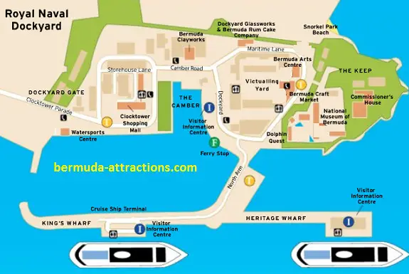
Dockyard Map Bermuda - A Schematic
Who This Map Guide Is For (And Who Can Skip It)
This guide is built specifically for passengers arriving on modern mega-ships operated by Norwegian, Royal Caribbean, Celebrity, and Carnival. If your itinerary says you are docking at the "Royal Naval Dockyard," "King's Wharf," or "Heritage Wharf," you are in the right place.
You can skip this specific map guide if you are sailing on a smaller luxury vessel like Oceania or Regent Seven Seas. Those smaller ships often bypass the West End entirely, docking right on Front Street in the City of Hamilton or at Penno's Wharf in St. George's.
The Cruise Berths: King's Wharf vs. Heritage Wharf
When you look at a port map, you will see two main piers jutting out into the Great Sound. These are King's Wharf and Heritage Wharf. They sit side-by-side, sharing the same massive concrete footprint.
Do not stress about which specific wharf your ship is assigned to. The distance between the two gangways is a flat, two-minute walk across open tarmac. Both berths funnel you into the exact same central plaza where the transport hubs and security gates are located.
Transport Hubs: How to Leave the Port
The most critical part of the port map is the transport zone. As soon as you clear the security checkpoint at the end of the pier, you will see a large, open staging area.
The Ferry Dock: Look to your immediate left after exiting the ship area. The ferry stop is a 5-minute walk over flat ground. You will catch the year-round Blue Route ferry to Hamilton or the seasonal Orange Route ferry to St. George's here.
The Public Bus Stop: Located just past the ferry terminal, near the entrance to the Clocktower Mall. Look for the pink and blue poles. Route 7 is your ticket to the famous South Shore beaches.
The Taxi Stand: Directly in front of the cruise ship exit. Taxis line up early, but the queue gets long by 9:30 am.
Mini-Car Rentals: Rental hub for electric two-seaters is located near the Clocktower Mall. Book these months in advance, as the physical kiosks rarely have walk-up inventory.
Scooter Rentals: Oleander Cycles located at Dockyard Terrace rents scooters and bicycles.
Note on Parking: For scooters and EV mini-cars, the free and primary designated public parking lot is located right across the street from the Clocktower Mall. There are also free but limited parking bays near the cruise pier exit gate for short-term parking.
Essential Amenities on the Map
Knowing where the basic facilities are can save your morning. The
Visitor Service Center (VSC) is located right near the ferry terminal. This is where you buy your public transport passes, but expect a line right after a ship clears.
Public restrooms are scattered throughout, with the largest and cleanest blocks located inside the Clocktower Mall and near the ferry terminal.
If you need cash, there are ATMs inside the mall and near the main transport plaza. Be aware that while most of Bermuda takes credit cards, some smaller transport operators and independent market vendors still prefer cash.
What Surprises Visitors the Most About the Layout
The sheer scale of the Dockyard catches most first-timers off guard. Maps often make the complex look like a compact shopping village. In reality, walking from your ship all the way to the
National Museum of Bermuda at the far end of the fortress takes about 15 minutes.
The heat radiating off the limestone buildings and tarmac in July and August is intense. There is very little natural shade between the major attractions. If you have mobility issues, or just want to save your energy, look for the Free Dockyard Shuttle Train. It runs a continuous loop around the complex, stopping at all major zones.
Walking the Dockyard: Key Zones and Distances
To make the map useful, I break the Dockyard down into three walkable zones. Treat the cruise ship exit as your starting point for all distances.
Zone 1: The Keep and History
The massive stone fortress at the very tip of the peninsula is called The Keep. A 10-minute walk from the ship brings you to the entrance. Inside, you will find the sprawling
National Museum of Bermuda. The popular
Dolphin Quest enclosure is also located inside the museum grounds, utilizing the old naval pond.
Zone 2: Shopping
If you walk straight from the ship for about 7 minutes, you will hit the iconic twin clock towers. The
Clocktower Mall houses local boutiques and air-conditioned relief. Just inside, you will find
Studio 8 Glass. This modern glass art studio is the current replacement for the old Dockyard Glassworks that closed a few years ago.
Zone 3: Food and Beach
Hungry visitors should head toward the historic Victualling Yard, about an 8-minute walk from the berths. Here you will find the famous
Frog and Onion Pub, perfect for a pint and some local fish chowder spiked with black rum and sherry peppers.
For a quick coffee or light bite, look for The Dockyard Cafe, which recently took over the old Pastry Shop location. Just behind the pub walls is
Snorkel Park Beach, the only beach physically located inside the port complex.
Royal Naval Dockyard Road Map
Click on the Blue Markers to know each Landmark
The Free Shuttle to Avoid Walk
If you want to avoid walks around the dockyard, you can avail the free trolley. The Free Dockyard Courtesy Shuttle is an open-air electric tram that loops continuously around the Royal Naval Dockyard.
It picks up passengers at the main exit shared by the cruise piers and stops at the Ferry Dock, Visitor Services Center (VSC), Clocktower Shopping Mall, Snorkel Park Beach entrance, the National Museum of Bermuda/Victualling Yard entrance, and the Bermuda Craft Market before returning to the cruise berths.
The shuttle operates daily from 9:00am to 6:00pm during the summer cruise season.
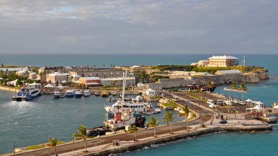
Dockyard View from Heritage Wharf
Photo: James Willamor, flickr, cc by-sa 2.0
Common Navigation Mistakes
The most common spatial error is misjudging the walk back to the ship. Visitors often lose track of time at the Frog and Onion Pub and assume they can sprint back to the gangway in two minutes. The cobblestones are uneven, and the crowds move slowly. Always leave yourself a 15-minute buffer to walk back.
Another frequent mistake is ignoring the ferry cutoff times. The last ferry from Hamilton back to the Dockyard map zone leaves strictly on schedule. If you miss it, you are looking at a very expensive, 45-minute taxi ride across the island to get back to your ship.
Alternatives to the Dockyard
If you look at the map and realize a commercialized naval fortress is not your vibe, use the transport hub immediately. The Dockyard is the perfect launchpad to explore the rest of the island.
Grab a ferry token and take the scenic 20-minute ride across the Great Sound to Hamilton. Alternatively, hop on the Route 7 bus and head straight to Horseshoe Bay. The port is designed to get you moving, so do not feel obligated to spend your entire day within the fortress walls.
About the Author
 By Raj Bhattacharya
Raj has been writing about Bermuda since 2008, when he launched bermuda-attractions.com, one of the longest-standing independent guides to the island. A Certified Bermuda Specialist (Bermuda Tourism Authority), his work draws on personal visits, local contacts in Bermuda, and questions and trip reports from thousands of readers over the years.
Learn more about Raj Bhattacharya
Related Articles
|
Visitors' Reviews and Comments
|