We earn a commission from third-party booking links, at no extra cost to you
Bermuda Tourist Map: Regional Zones & Attraction Locations
Updated: November 2026
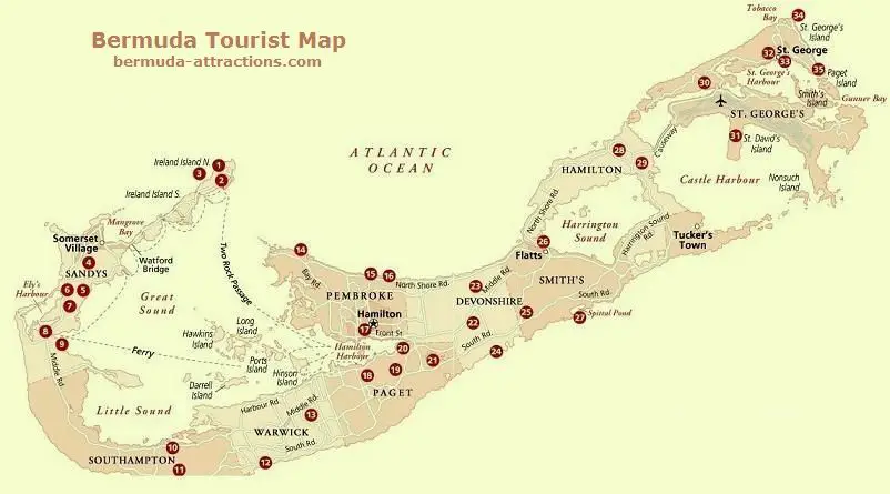
Bermuda is shaped like a fishhook, stretching just 21 miles from end to end. Understanding how its top sights are scattered across the parishes is the key to building a realistic itinerary.
If you just look at a list of
things to do without a spatial reference, you will likely spend half your vacation in transit.
I designed this guide to help you visualize the island's layout before you arrive. By breaking the map down into three main zones, you can group your activities logically.
Cartography courtesy of Frommer's Travel Guides
At a Glance
| Feature |
Details |
| Best Time to Go |
May through October for warm water |
| Total Cost Estimate |
High (Expect $250 - $400+ per day) |
| Ideal Duration |
5 to 7 days to see all three zones |
| Primary Transport |
Electric micro-cars, scooters, public buses, and ferries |
How to Read Bermuda's Layout (West, Central, and East)
Despite its small size, navigating Bermuda takes time due to narrow, winding roads and a strict 20 mph speed limit.
You cannot rent a standard car here. Visitors rely on public transport, taxis, scooters or two-seater electric vehicles.
To save time and money, you should divide the island map into three distinct regions. The West End contains the major cruise port and naval history. Central Bermuda is the commercial hub. The East End holds the oldest settlements and natural cave systems.
Pro-Tip: Zoning Your Trip
Focus on one zone per day. Trying to cross the island from the Royal Naval Dockyard to St. George's by road will eat up over an hour of your travel time each way.
Interactive Bermuda Tourist Map (Site Location Map)
Zone 1: The West End and Royal Naval Dockyard (Map Highlights)
The West End is dominated by the Royal Naval Dockyard, a massive stone fortress that now serves as the island's primary cruise ship terminal. This area is highly walkable but gets incredibly crowded when multiple ships are in port.
Your first stop on this side of the map should be the National Museum of Bermuda. It covers 15 acres of fortress and provides brilliant context for the rest of your trip. Just outside the museum gates, you will find Snorkel Park and Beach, which is convenient but often packed with day-trippers.
As you travel east from the Dockyard into Southampton Parish, you will hit Horseshoe Bay Beach. It features the island's most famous stretch of pink sand, but it gets extremely busy, so arrive before 10 am if you want to secure a rental chair and umbrella.
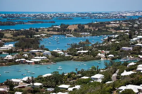
Just inland from the beach, you can climb the 185 cast-iron steps of Gibbs Hill Lighthouse. The steps are steep and the wind at the top is fierce, but the panoramic view of the Great Sound is unmatched.
View from the top of the lighthouse
View All West End Attractions
Zone 2: Central Bermuda and Hamilton (Map Highlights)
Central Bermuda is anchored by the City of Hamilton. This is where you will find the heaviest traffic, the main bus terminal, and a dense concentration of restaurants, bars and shops along Front Street.
Just outside the city center sits the Bermuda Underwater Exploration Institute (BUEI). It is a fantastic, air-conditioned escape on a humid afternoon. A short drive away, the Botanical Gardens offer a quiet walk, though the signage can sometimes be confusing, so pay attention to the main paths.
Heading slightly east into Flatts Village, the map pinpoints the Bermuda Aquarium, Museum and Zoo. The facility is built right on the edge of the water. You can smell the salt air mixing with the dense tropical foliage as you walk through the outdoor exhibits.
View All Central Attractions
Zone 3: The East End and St. George's (Map Highlights)
The East End is the historical heart of the island. The Town of St. George is a UNESCO World Heritage site filled with narrow, cobblestone alleys.
The biggest draws in this zone are the Crystal and Fantasy Caves. Be prepared for a micro-friction here: the pontoon bridge inside the cave can be slick, and the humidity underground is heavy. Wear shoes with good grip.
On the northern tip of this zone sits Fort St. Catherine. The massive stone walls drop directly down to the jagged coral rock below. Nearby, you will find the striking stone arches of The Unfinished Church, which makes for an excellent, quick photo stop.
View All East End Attractions
What Surprised Me the Most About Bermuda's Geography
When I first started mapping out my routes, I did not realize how useful the Bermuda Railway Trail would be. This abandoned rail bed spans 18 miles across the island.
It completely changes how you experience the map. Instead of fighting traffic on Middle Road, you can walk or rent a bike to travel between several attractions completely off the main grid.
Common Mistakes When Mapping Out Your Trip
The most common error is underestimating travel times. A distance of 10 miles looks like a quick 15-minute drive on paper. In reality, with blind corners, roundabouts, and slow-moving traffic, it will take much longer.
Another frequent mistake is relying strictly on buses to cross the Great Sound. If you are traveling between the Dockyard and Hamilton, or between Dockyard and St. George (in summer), the Sea Express ferry is significantly faster and offers a much better view.
Pro-Tip: Cash and Transport
If you take the pink and blue public buses, you must have exact change in coins or a pre-purchased pass or token. The drivers will not accept paper bills.
Practical Details: Navigating the Map
Getting between the points on your map requires a bit of planning. Here is how you can move around efficiently:
Scooters: Renting a Scooter is the traditional way to explore the island's map and offers total freedom. However, mopeds are not for beginners. You must be highly alert and comfortable driving on the left side of narrow, shoulderless roads.
Electric Micro-Cars: If you want the independence of a scooter but prefer four wheels and a roof, look into
micro-car rentals like the Twizy. They are safer and enclosed, though you still need confidence to navigate tight corners alongside large commercial trucks.
Public Buses: The
bus routes span out from the Central Terminal in Hamilton. Pink poles indicate buses heading toward Hamilton; blue poles indicate buses heading away.
Sea Express Ferries: Public Ferry is the most scenic way to connect the West End to Central Bermuda. Check the seasonal schedule, as winter routes are limited.
Who This Island-Wide Map is For (And Who Should Skip It)
This macro map overview is perfect for first-timers, families, and itinerary planners who need to grasp the big picture.
However, if you are a cruise visitor docking at King's Wharf for only a few hours, you should skip this island-wide view. You will be better served focusing purely on a localized
Dockyard map to maximize your short time ashore.
Alternatives: Specialized Bermuda Maps
If this island-wide overview is not exactly what you need, we have more specific resources available.
About the Author
 By Raj Bhattacharya
Raj has been writing about Bermuda since 2008, when he launched bermuda-attractions.com, one of the longest-standing independent guides to the island. A Certified Bermuda Specialist (Bermuda Tourism Authority), his work draws on personal visits, local contacts in Bermuda, and questions and trip reports from thousands of readers over the years.
Learn more about Raj Bhattacharya
Related Articles
1) Check out
Bermuda Map for all the maps that you will ever need in Bermuda.
2) Check out
Bermuda Guide for lot more information about Bermuda.